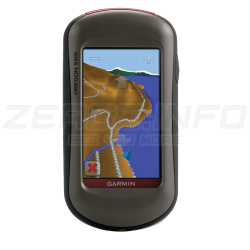
GARMIN OREGON 550t GPS
The navigator with photographic memory! Oregon 550t combines rugged outdoor touchscreen navigation with a 3.2 megapixel digital camera. Add preloaded U.S. topographical maps, high-sensitivity GPS, barometric altimeter, 3-axis electronic compass and microSD™ card slot, and what do you get? A multipurpose device that will make your biggest adventures even more memorable.
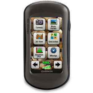
Take Pictures and Save Locations
Capture locations and memories with Oregon 550t's 3.2 megapixel autofocus digital camera with 4x digital zoom. Each photo is geotagged automatically with the location of where it was taken, allowing you to navigate back to that exact spot in the future. Snap and view pictures in landscape or portrait orientation. With 850 MB of internal memory, you'll never miss a photo opportunity. To store online, simply connect Oregon 550 via USB and visit myDashboard to storage/files/uploads and store your photos at Picasa™, a popular online photo sharing community. For more storage, insert a microSD card; you even can view pictures from other devices on microSD with Oregon's picture viewer.
Touch and Go
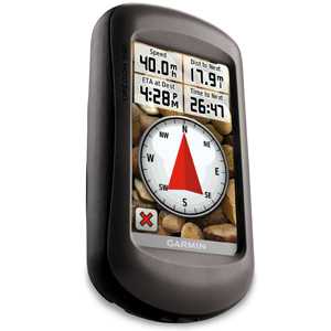
Oregon 550t makes rugged navigation effortless with a tough, 3" (7.62 cm) diagonal, sunlight-readable, color touchscreen display. The interface is easy to use, so you’ll spend more time enjoying the outdoors and less time searching for information. Both durable and waterproof, Oregon 550t is built to withstand the elements; bumps, dust, dirt, humidity and water are no match for this rugged navigator.
Explore the Terrain
Oregon 550t comes with built-in U.S. topographic data for the continental U.S. and a worldwide basemap with shaded relief — all the tools for serious climbing or hiking. Map detail includes national, state and local parks and forests, along with terrain contours, elevation information, trails, rivers, lakes and points of interest.
Get Your Bearings
Oregon 550t has a built-in 3-axis tilt-compensated electronic compass, which shows where you're heading even when you’re standing still, without holding it level. Its barometric altimeter tracks changes in pressure to pinpoint your precise altitude, and you even can use it to plot barometric pressure over time, which can help you keep an eye on changing weather conditions. And with its high-sensitivity, WAAS-enabled GPS receiver and HotFix® satellite prediction, Oregon 550t locates your position quickly and precisely and maintains its GPS location even in heavy cover and deep canyons.

Share Wirelessly
With Oregon 550t you can share your waypoints, tracks, routes and geocaches wirelessly with other compatible Oregon, Colorado® and Dakota® users. Now you can send your favorite hike to your friend to enjoy or the location of a cache to find. Sharing data is easy. Just touch “send” to transfer your information to similar units.
Add Maps
Adding more maps is easy with Garmin's wide array of detailed topographic, marine and road maps. With its microSD™ card slot, Oregon 550t lets you load TOPO U.S. 24K maps and hit the trail, plug in BlueChart® g2 preloaded cards for a great day on the water or City Navigator map data for turn-by-turn routing on roads (see maps tab for compatible maps). Oregon 550t also supports BirdsEye Satellite Imagery (subscription required), that lets you download satellite images to your device and integrate them with your maps.
Find Fun
Oregon 550t supports OpenCaching.com GPX files for downloading geocaches and details straight to your unit. By going paperless, you're not only helping the environment but also improving efficiency. Oregon stores and displays key information, including location, terrain, difficulty, hints and descriptions, which means no more manually entering coordinates and paper print outs! Simply storage/files/uploads the GPX file to your unit and start hunting for caches. Show off photos of your excursions with Oregon’s picture viewer. Slim and lightweight, Oregon is the perfect companion for all your outdoor pursuits.
Plan Your Next Trip
Take charge of your next adventure with BaseCamp™, software that lets you view and organize maps, waypoints, routes, and tracks. This free trip-planning software even allows you to create Garmin Adventures that you can share with friends, family or fellow explorers. BaseCamp displays topographic map data in 2-D or 3-D on your computer screen, including contour lines and elevation profiles. It also can transfer an unlimited amount of satellite images to your device when paired with a BirdsEye Satellite Imagery subscription.