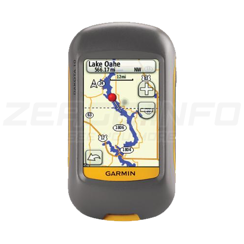
GARMIN DAKOTA 10
Outdoor navigation meets touchscreen simplicity in Dakota 10. This rugged, palm-sized navigator boasts touchscreen navigation, high-sensitivity GPS with HotFix® satellite prediction, and a worldwide basemap in one affordable, power-packed punch.
Touch and Go
Dakota 10 makes outdoor navigation effortless with a tough, sunlight-readable, 2.6 inch color touchscreen display. The interface is easy to use, so you’ll spend more time enjoying the outdoors and less time searching for information. Both durable and waterproof, Dakota 10 is built to withstand the elements: bumps, dust, dirt and water are no match for this rugged navigator.
Find Fun
Get into paperless geocaching with Dakota 10 by quickly downloading up to 2,000 caches, with information such as location, terrain, difficulty, hints and description — no more paper print outs and manually entered coordinates. Visit our geocaching pages for more information.
Explore the Terrain
Dakota 10 comes with built-in worldwide basemap, so you can navigate anywhere with ease. Adding more maps is easy with Garmin's wide array of detailed topographic, marine and road maps, which can be loaded to internal memory.
Get Connected
You've been busy exploring and now you want to store and analyze your activities. With a simple connection to your computer and to the Internet, you can get a detailed analysis of your activities and send tracks to your outdoor device using Garmin Connect™. This one-stop site offers an activity table and allows you to view your activities on a map using Google™ Earth. Explore other routes storage/files/uploadsed from over 12 million customers and share your experiences on Twitter® and Facebook®. Getting started is easy, so get out there, explore, and share.
Plan Your Next Trip
Take charge of your next adventure with BaseCamp™, software that lets you view and organize maps, waypoints, routes, and tracks. This free trip-planning software even allows you to create Garmin Adventures that you can share with friends, family or fellow explorers. BaseCamp displays topographic map data in 2-D or 3-D on your computer screen, including contour lines and elevation profiles. It also can transfer an unlimited amount of satellite images to your device when paired with a BirdsEye Satellite Imagery subscription.
GARMIN Dakota 10
010-00781-00
This rugged, palm-sized navigator boasts touchscreen navigation, high-sensitivity GPS with HotFix® satellite prediction, and a worldwide basemap in one affordable, power-packed punch.
Discontinued product.
SPECS
Technical specifications
Button lock or Locking the Touchscreen
CLOCK MODE
12/24h
Calendar clock
PRE-TRAINING FUNCTIONS
Sports profile settings
Adjustable recording rate
automata
COMPUTER CONNECTIVITY
Data transmission device in the package?
Driver Name
Garmin Express
Compatible with PC
Compatible with Mac
NAVIGATION FEATURES
Displays the coordinates
Track and POIs on display at the same time
Can be filled from the GPS Trace
Routes
50
Show the map on device
zoom in or out
GPS FUNCTIONS
Tide database
Sun and moon information
Area calculation
Outdoor GPS games
HUNTING & FISHING
Hunt/fish calendar
Description
GARMIN DAKOTA 10
Outdoor navigation meets touchscreen simplicity in Dakota 10. This rugged, palm-sized navigator boasts touchscreen navigation, high-sensitivity GPS with HotFix® satellite prediction, and a worldwide basemap in one affordable, power-packed punch.
Touch and Go
Dakota 10 makes outdoor navigation effortless with a tough, sunlight-readable, 2.6 inch color touchscreen display. The interface is easy to use, so you’ll spend more time enjoying the outdoors and less time searching for information. Both durable and waterproof, Dakota 10 is built to withstand the elements: bumps, dust, dirt and water are no match for this rugged navigator.
Find Fun
Get into paperless geocaching with Dakota 10 by quickly downloading up to 2,000 caches, with information such as location, terrain, difficulty, hints and description — no more paper print outs and manually entered coordinates. Visit our geocaching pages for more information.
Explore the Terrain
Dakota 10 comes with built-in worldwide basemap, so you can navigate anywhere with ease. Adding more maps is easy with Garmin's wide array of detailed topographic, marine and road maps, which can be loaded to internal memory.
Get Connected
You've been busy exploring and now you want to store and analyze your activities. With a simple connection to your computer and to the Internet, you can get a detailed analysis of your activities and send tracks to your outdoor device using Garmin Connect™. This one-stop site offers an activity table and allows you to view your activities on a map using Google™ Earth. Explore other routes storage/files/uploadsed from over 12 million customers and share your experiences on Twitter® and Facebook®. Getting started is easy, so get out there, explore, and share.
Plan Your Next Trip
Take charge of your next adventure with BaseCamp™, software that lets you view and organize maps, waypoints, routes, and tracks. This free trip-planning software even allows you to create Garmin Adventures that you can share with friends, family or fellow explorers. BaseCamp displays topographic map data in 2-D or 3-D on your computer screen, including contour lines and elevation profiles. It also can transfer an unlimited amount of satellite images to your device when paired with a BirdsEye Satellite Imagery subscription.
In the box / Warranty
WHAT'S IN THE BOX?
- Dakota 10
- Lanyard
- USB cable
- Manuals
Accessories
Product accessories
Similar products
Similar products
SUPPORT